The publication of a regional survey might seem more likely to inspire specialist perusal than wanderlust. Arriving as it does during the COVID pandemic, though, Cornelia Römer (et al)’s[1] book is a particular treat, as it lets us stroll the Fayum with her team, and make the sort of journeys of exploration that have been, and may remain for some time to come, impossible or imprudent. In any time, however, Römer’s book will have value, and represents a major resource for our study of the ancient Fayum.
The Fayum depression sits southwest of Cairo today, to the west of the Nile valley, to which it was linked by a branch canal. It underwent extensive drainage and development works in the Ptolemaic period, when it was organized as the Arsinoite nome and divided into three districts (merides): the divisions of Polemon in the south, Themistos in the northwest, and Herakleides in the east. It is the Themistou meris that forms the focus of this volume. This area was home to a number of (relatively) well-known sites—Theadelpheia, Euhemeria, Philoteris, and Dionysias most notably. As a survey of the Themistou meris, Römer’s work is not oriented around a single overarching interpretive question; rather it provides a stimulating archaeological and papyrological itinerary of those sites and the wider region, organized as a series of entries by site. As Römer acknowledges, “the task of the team and myself was to survey the whole of the ancient Themistou Meris” (1). Each entry, therefore, follows a somewhat similar trajectory. To take one example, Chapter 13 (Batn Harit/Theadelphia) covers the site itself and its geographical location, how to visit it today, the papyrological evidence for the village, descriptions of the area from al-Nabulsi to the 1930s, surviving architecture (including baths, vats, and perhaps wineries), cemeteries, nearby canals referenced in papyri, “inscriptions and their value for our understanding of the layout of the settlement,” and finally brief descriptions of the ten papyrological archives found there. This all is accompanied by a handsome, full-color map, 11 plans and drawings, and 65 historic and contemporary photos, most in full color. And this is but one of the thirty chapters. The precise nature of each chapter varies slightly depending on the subject and whatever interpretive questions are most relevant to that site.
One strength of Römer’s work is that she makes space for the richness of the settled landscape around the major villages—we know of a large number of hamlets, farmsteads, mines, and so on that dotted the Fayumic landscape, and many find their way into the present work. This constellation of large and small settlements, water features, and so on, is discussed by Römer holistically, drawing in evidence from papyri, archaeology, travelers’ descriptions from medieval to modern, maps, aerial photographs, and Römer’s own insights from her decades of work in the region.[2] The breadth and scale of the work is significant, and offers a vivid testament to the necessity of interdisciplinary approaches. Here, archaeology, papyrology, and other disciplines are not separate fiefdoms dragged unwillingly into temporary alliance, but instead opportunities for collaboration and conversation. Indeed, while billed as an “Archaeological and Papyrological Survey,” it is much more than that, taking in as well the post-classical history of the region, up to and including modern settlement, and its effects on sites, many of which have changed dramatically just in the time Römer has been working.
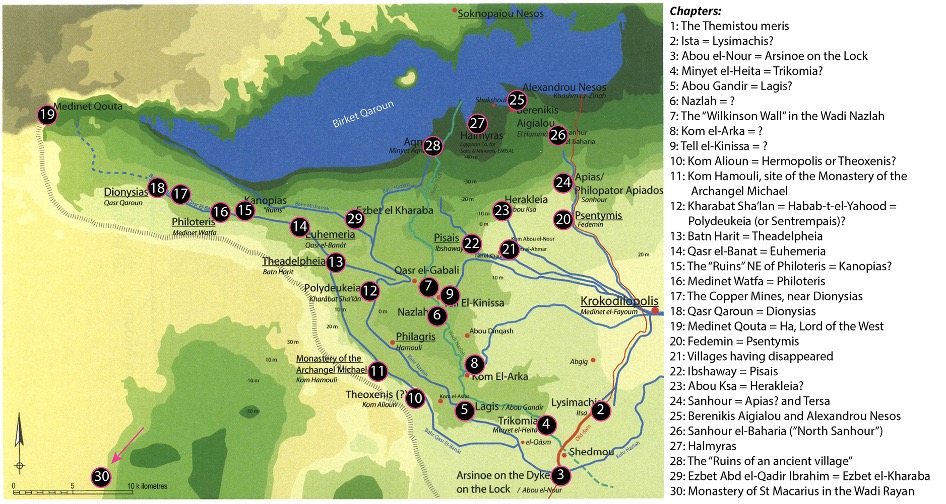
Römer’s work fits into a very long tradition of surveys of the Fayum, from al-Nabulsi to Caton-Thompson and Gardner, Bernand, and the more recent Fayum Project gazetteer undertaken twenty years ago under the direction of Willy Clarysse and Katelijn Vandorpe. In this case, though, by focusing only on the Themistou meris, and by incorporating the results of her own on-the-ground survey and excavations, Römer can provide a more detailed, comprehensive study of these sites.[3] Indeed, the depth of her expertise is apparent on every page, flowing on from her more than two decades of work in the area with the Fayoum Survey Project. If one could at the same time raise a querulous note, however, it might be that a casual reader would likely benefit from a more fulsome introduction, and a discussion of the guiding principles by which the work is organized. This stands out particularly where it concerns the structure of the volume: quite reasonably, (nearly) every settlement is given its own chapter, but the itinerary from settlement to settlement, like that of many an ancient author, is that of the traveler rather than following the alphabet, cardinal directions, or a grid.[4] The chapters do form a coherent trajectory, tracking along the wadis, swinging along the desert edge, and so on, but the reasons for these are not much discussed, and the absence of guide resources may form a barrier to casual engagement with Römer’s work. I numbered the following map (edited from Römer’s own, excellent plan of the meris) to illustrate the topic and location of each of the book’s 30 chapters. Such a map, or even better, a discussion of the structure as part of the book’s introduction, would be a welcome aid to orient the reader, rather than beginning in medias res with the damming of cross-Fayum drains.
Yet, there is a virtue in the decision to structure the chapters as they are. Many of us, even those who research everyday life in the ancient Fayum, are accustomed to think of the region from a top-down perspective, according to the maps we regularly consult or reproduce. But the experience of the ancient people was of course very different—they walked the wadis, sailed the great Moeris lake, or toiled for days on the dikes and canals that criss-crossed the region. Theirs was a ground-level perspective. By organizing the work as they have, Römer and her team force us to re-center the landscape and topography. The economies, relationships, and lives of the villages that were strung out along the line of the Bahr Qasr el-Banat, the irrigation canal that ran along the desert edge at least as far as Dionysias (today, Qasr Qaroun), are more legible and meaningful when we too have followed that canal from the center to Medinet Qouta, on the slopes rising west of the Fayum. By the time one reaches that settlement, one can almost see the last drops of the canal trickling away into the earth. This volume presents the region as seen from ground-level (or, indeed in many places, from below sea level). Römer supports this by offering at times advice on locating a site, or the logistics of visiting it, though these are a little too irregularly offered, and the book perhaps a little too large to really be of use as a pocket-guide to the region.
It may be, though, that many (perhaps, most) will engage with this volume in a more ad hoc fashion, consulting it as a reference for information on a specific site rather than an itinerary through the meris. In this they will be well supplied. Indeed, when it comes to the settlements themselves, there is a treasure trove of insights and information, brought to light by Römer’s expertise and ability to bring a host of scholarly debates into the same forum. Not every argument need convince—by way of example, I suspect the relationship between the ancient farmstead/hamlet of Pisais and modern Ibshaway might be somewhat more complex than Römer argues. But almost every page will bring something new. Those interested in the complex dance of international relations in the early years of the Hellenistic period, for instance, will appreciate the commemoration of Lysimachus and Arsinoe’s brief marriage through the naming of settlements (Lysimachis and Arsinoe on the Lock, respectively) in their honor at either end of a dike.[5] A small number of thematic chapters or appendices, accompanying the two by Ilka Klose and Peter Klopp on the geomorphology of Philoteris and excavations there in 2012 and 2014, might have helped to highlight this material for a wider audience who might not otherwise pick up a regional survey.
To turn to the physical book itself: this is a large, well-assembled paperback, on heavy paper, with illustrations (including color photographs) on almost every page, and a packet stuffed full of fold-out maps tucked into the back cover. Amidst this praiseworthy richness, it seems almost churlish to point them out, but there are an above-average number of typos in the text. Most are easily overlooked, though a few do affect meaning: the Wadi Heitan, for instance, is referred to as “The Valley of the Wales,” but is instead the Valley of the Whales, for the stunning marine fossils found there. One might also note a few instances of imprecise language, as for instance, the use of “ancient” to mean both pre-medieval and “somewhat old,” as with an “ancient railway” said to date to the first half of the 19th century (13),[6] or the “ancient village” of Kom el-Asfar.
After thousands of years of human occupation, the Fayum continues to change. One point made clear by Römer’s work is the pace of this change, as many sites were lost just in the past couple of decades. This volume will be a valuable resource for any seeking to understand the settlements of the Themistou meris, and will be doubly valuable once many of the places Römer and her team explored are no longer visible or intact. While one can expect that the audience will chiefly be papyrologists and archaeologists working in the region—for whom this will be a welcome and frequent companion—this is a fine example of interdisciplinary work on a regional scale, and there will be much here too for those interested in a range of topics, from the Middle Kingdom to medieval Christianity and modern Egypt.
Notes
[1] Most of the book is by Römer herself, with one chapter, on the copper mines near Dionysias, by Fatma Hamouda, and two appendices on Philoteris by Ilka Klose and Peter Klopp.
[2] This praise goes as well for Fatma Hamouda’s chapter on the copper mines near Dionysias.
[3] It should be noted that this aspect is further developed by the late DM Bailey’s companion volume, surveying the ceramic evidence, released alongside this volume.
[4] Unlike, for instance, al-Nabulsi, who followed first-letter alphabetization. For more, see J.G. Keenan, “Landscape and Memory: al-Nabulsi’s Ta’rikh al-Fayyum,” Bulletin of the American Society of Papyrologists 42 (2005), 203-212.
[5] For these, see Chapters 2 and 3. Arsinoe on the Lock (ἐπὶ τοῦ ζεύγματος) was also referred to as Arsinoe on the Dike (ἐπὶ τοῦχώματος).
[6] An improbably early date since the first railway in Egypt is usually dated to the 1850s, linking Alexandria and Cairo.